B05
Towards a dynamic representation of irrigation in land surface models
Prof. Dr. Stefan Siebert
University of Göttingen | +49 551 39-24359 |
Dr. Wanxue Zhu
University of Göttingen | +49 551 39-24361 |
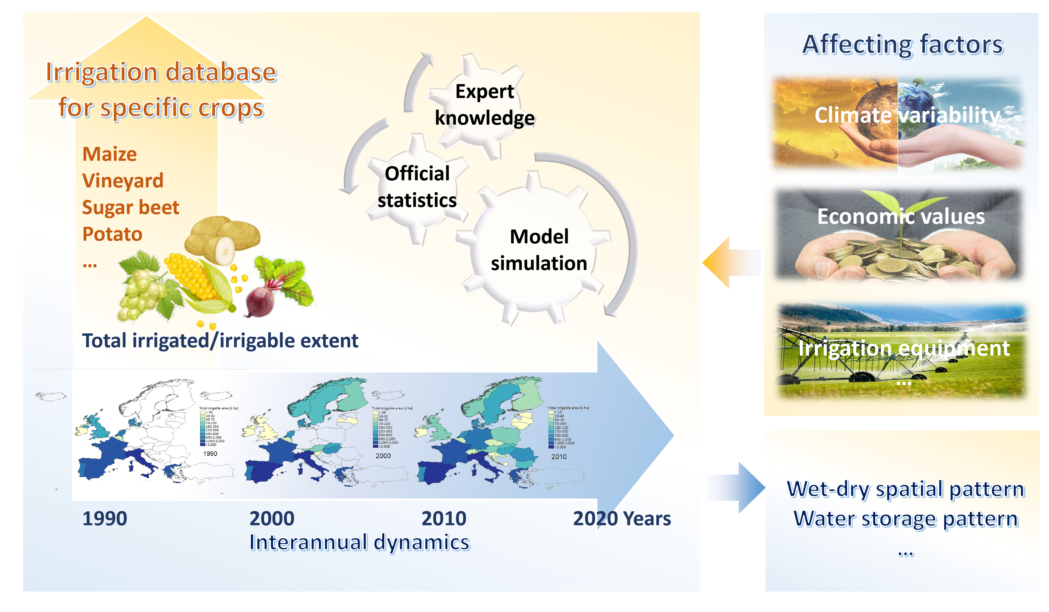
Summary
In B05 we analyze the impact of climate variability on the extent of irrigated crops, irrigation water requirements, and irrigation water use. The impact of the dynamic irrigation data on spatial patterns, dynamic trends of water storages, and related drying and wetting patterns across the project regions will be analyzed as well. To achieve the objectives, we systematically collect sub-national statistics providing the extent of irrigated lands (total and for specific crops) for the Europe / Euroasia modeling domain for the period since 1990. The survey based statistics are combined with an annual drought indicator computed with the Global Crop Water Model (GCWM) to obtain relationships between the extend of irrigated land and the drought condition in the specific years. Then these relationships are being applied to gap-fill the available survey based statistics. Using high resolution crop shares provided by B04 and data for area equipped for irrigation, the sub-national statistics are dis-aggregated to obtain a novel dataset of annual irrigated and rainfed crop shares at 1 km resolution, across Europe and for the period since 1990. The new annual irrigation database will be applied in community land model (CLM) to quantify differences in dynamics and trends of irrigation water use across the region compared to the use of the current static data products and to quantify the impact of irrigation on the regional climate. This requires close collaboration with C01, D02 and Z04.
Graphical Summary
Contribution to CRC
To test the central hypothesis of the CRC project, it is needed to develop datasets and methods to quantify the annual extent of specific irrigated crops dynamically in response to climate variability, site conditions, and crop characteristics. In collaboration with several other projects (B04, A05, C01, and A06), B05 isl developing new datasets and innovative methods to improve the implementation of irrigation water use in the CRC IMS and thereby helps to better quantify human impacts on the water cycle and energy fluxes. In particular, the focus on interannual variability in land use and water withdrawals in dry years is essential to better quantify and interpret human interventions in the water and energy cycle for relatively humid regions. Therefore, B05 is considerably contributing to the CRC’s key objectives.
Approach
We will collect ground survey data about sub-national irrigated/irrigable extents, methods, and sources for specific crops and years from official statistical departments to generate a standard irrigation database from 1990-2020. The relationships between observed and simulated crop-specific irrigation requirements from the modified global crop water model-GCWM (Siebert and Döll, 2010) will be evaluated to fill the temporal and spatial gaps of the irrigation database; the uncertainties of database generation will be discussed. Factors affecting the dynamic trends of irrigation water use across regions such as potential evapotranspiration, inter-annual variability, crop economic values, and the area equipped for irrigation will be evaluated using the regression analyses. In collaboration with other subprojects to parameterize the CLM for the different irrigated crops and apply CLM for the period 1990-2020 to compute irrigation water requirements based on the present static crop irrigation shares and the improved dynamic crop irrigation shares, to check the consistency of GCWM results and evaluate the impacts of dynamic irrigation data on spatial patterns, dynamics, and trends of water storages, and related drying and wetting patterns across the project region for the period 1990-2020.
Main results in 2022
We have collected and generated the standard irrigation database across Europe/Euroasia regions for the period 1990-2016 with a temporal resolution of around three years, mainly at the NUTS2 level, and for specific years such as 2010, the NUTS3 level database for some countries is available. These irrigation databases include the total irrigable and irrigated extents, and irrigation information for specific crops. Irrigation sources, methods, and management are available for 2010. Blue and green water use of irrigated crops at the grid and NUTs levels for the period 1990-2020 has been calculated using the GCWM forced with ERA5 daily climate information. An abstract focusing on the methodology to develop the European Irrigation Database was submitted to EGU 2023. This preparation work is essential for subsequent analysis, the current database was delivered to other CRC projects for primary analysis and model development.
Main results in 2023
We have developed the European Long-term Irrigation Area Dataset (ELIAD), which provides subnational annual total irrigable and irrigated areas across 32 European countries from 1990 to 2020. The irrigable area refers to the cropland extent equipped with irrigation infrastructure, while the irrigated area refers to the extent of cropland that actually received irrigation. Except for the data in the United Kingdom and Germany, which are at the NUTS1 level, all other data are at the NUTS2 level. The generation of ELIAD irrigated area considered the availability of irrigation infrastructure and the drought conditions simulated by the GCWM model on the use of irrigation infrastructure. Additionally, datasets on European irrigation blue and green water use for crops, as well as drought conditions for the period 1990–2020, have been made available. Two conference papers were submitted to the EGU2023 General Assembly and the GPW2023 Conference. A research paper related to the generation of ELIAD data has been submitted for peer review.
Main results in 2024
In collaboration with subproject B04, which provided annual 1 km resolution crop-specific cultivated area data for 28 European countries from 2010 to 2020, we developed a new dataset: ECIRA (European Crop-specific Irrigation Area dataset). ECIRA integrates the high-resolution crop distribution data from B04 with our sub-national annual irrigation area dataset (ELIAD), as well as data from EUROSTAT 2010 and GMIA v5.0. This integration enables the spatial allocation of subnational total irrigation area to individual 16 crops (i.e., maize, rice, other cereals (excluding maize and rice), pulses, potato, sugar beet, rapeseed (rape and turnip rape), sunflower, textile crops, fresh vegetable & melon & strawberry in open fields, grassland, fruit and berry, citrus, olive, vineyard, and other crops) at 1 km resolution across Europe, offering a more detailed and crop-explicit representation of irrigation distribution for the period 2010–2020. Besides, we provided subproject D02 with global 40-year datasets of crop-specific blue water use, green water use, and actual evapotranspiration, derived from GCWM model simulations.
The study describing the development of the ELIAD dataset has been published in Communications Earth & Environment (Zhu and Siebert, 2024), while the manuscript describing ECIRA dataset has been submitted to Scientific Data for peer review. In addition to these project-specific outcomes, we also contributed to global scale studies being result of internal (Li et al., 2024) or external (Gu et al., 2024; Mehta et al., 2024) collaborations.
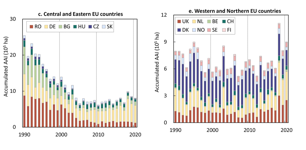
Different trajectories in the development of irrigated area: declining trend of irrigated area in Eastern Europe until about 2005 (left) while irrigated area in Western and Northern Europe shows a strong response to drought with largest irrigated area in the dry years 1995, 2003 and 2018 (extracted from Fig. 4 in Zhu and Siebert, 2024).
Main results in 2025
We further improved the dataset and released ECIRA Version 2 on Zenodo. In parallel, we developed a preliminary strategy to integrate ECIRA, MIRCA-OS, ELIAD, and national statistical data to produce a harmonized irrigation area product covering the DETECT Domain for the full period 1990–2020. In collaboration with subproject B04, we are conducting a review study on large-scale irrigation mapping. This review not only summarizes the current status of existing irrigation datasets, but also provides a systematic evaluation of all available products with a specific focus on Europe. The study identifies key challenges in mapping irrigation areas particularly for humid regions—such as limited ground truth, data consistency, and climate-induced uncertainties—and discusses potential pathways to overcome these limitations. The manuscript has been finalized and is presently prepared for submission.
The development of the ECIRA dataset and its validation has been published in Scientific Data (Zhu et al., 2025). In addition to this internal collaboration with B04, we also contributed to global scale studies being result of external collaborations (Heikonen et al., 2025; Kebede et al., 2025).
Publications
- Gu, W.; Wang, F.; Siebert, S.; Kummu, M.; Wang, X.; Hong, C.; Zhou, F.; Zhu, Q.; Liu, Y. & Qin, Y. The asymmetric impacts of international agricultural trade on water use scarcity, inequality and inequity. Nature Water 2, 324-336 (2024). https://doi.org/10.1038/s44221-024-00224-7
- Heikonen, S.; Heino, M.; Jalava, M.; Siebert, S.; Viviroli, D. & Kummu, M. Climate change threatens crop diversity at low latitudes. Nature Food 6, 331–342 (2025). https://doi.org/10.1038/s43016-025-01135-w
- Kebede, E. A.; Oluoch, K. O.; Siebert, S.; Mehta, P.; Hartman, S.; Jägermeyr, J.; Ray, D.; Ali, T.; Brauman, K. A.; Deng, Q.; Xie, W. & Davis, K. F. A global open-source dataset of monthly irrigated and rainfed cropped areas (MIRCA-OS) for the 21st century. Scientific Data 12, 208 (2025). https://doi.org/10.1038/s41597-024-04313-w
- Li, F.; Kusche, J.; Sneeuw, N.; Siebert, S.; Gerdener, H.; Wang, Z.; Chao, N.; Chen, G. & Tian, K. Forecasting Next Year's Global Land Water Storage Using GRACE Data. Geophysical Research Letters 51, e2024GL109101 (2024). https://doi.org/10.1029/2024GL109101
- Mehta, P.; Siebert, S.; Kummu, M.; Deng, Q.; Ali, T.; Marston, L.; Xie, W. & Davis, K. F. Half of twenty-first century global irrigation expansion has been in water-stressed regions. Nature Water 2, 254-261 (2024). https://doi.org/10.1038/s44221-024-00206-9
- Zhu, W. & Siebert, S. Climate-driven interannual variability in subnational irrigation areas across Europe. Earth Environ. 5, 1–13 (2024). https://doi.org/10.1038/s43247-024-01721-z
- Zhu, W., Baumert, J., Storm, H., Heckelei, T. & Siebert, S. ECIRA - European crop-specific irrigated area at 1 km resolution annually from 2010 to 2020. Data (2025). https://doi.org/10.1038/s41597-025-05628-y
-
Zhu, W., Dönmez, E., Storm, H., Heckelei, T., & Siebert, S. (2026). Large-scale irrigation area mapping: Status and challenges. Agricultural Water Management, 323, 110037. https://doi.org/10.1016/j.agwat.2025.110037
- Zhu, W. & Siebert, S. European Long-term Irrigation Area Datasets version 1.0. [Dataset] Zenodo https://doi.org/10.5281/zenodo.10715269 (2024).
- Zhu, W., Baumert, J., Storm, H., Heckelei, T. & Siebert, S. 1-km gridded European crop-specific irrigated area for each year from 2010 to 2020 (version 2). [Dataset] Zenodo https://doi.org/10.5281/zenodo.15569388 (2025).
Conferences Contributions
- Zhu, W. & Siebert, S. Towards a dynamic representation of irrigation in land surface models, EGU General Assembly 2023, Vienna, Austria, 24–28 Apr 2023, EGU23-8885.
https://doi.org/10.5194/egusphere-egu23-8885 - Zhu, W. & Siebert, S. Detecting the inter-annual variability in irrigation extent across Europe, GPW-Tagung 2023, Göttingen, 4–6 Oct 2023, 307-308.