D03
A fully coupled regional reanalysis framework
Dr. Jan Keller
Deutscher Wetterdienst | +49 69 8062 2859 |
Prof. Dr. Harrie-Jan Hendricks-Franssen
Forschungszentrum Jülich | +49 2461 614462 |
Dr. Arianna Valmassoi
Deutscher Wetterdienst | - |
Dr. Haojin Zhao (PostDoc)
Forschungszentrum Jülich | +49 2461 612822 |
Jane Roque Mamani (PhD student)
Universität Bonn | +49 228 735183 |
Summary
Reanalyses of various compartments of the terrestrial system have become an important tool in climate monitoring. Although the water cycle and its variations play a crucial role in the effects of climate change, the terrestrial water cycle has not been realistically represented in reanalyses. Further, the impact of human water use and especially irrigation have not yet been accounted for in reanalyses. Project D03 therefore aims to establish a fully coupled reanalysis system to provide estimates in a comprehensive and consistent framework.
Graphical summary
Contribution to the CRC
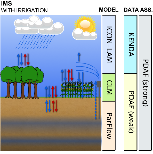
Our main contribution to the CRC is through the establishment of the IMS and the production of the reanalyses. Specifically, the IMS should allow for an otherwise unfeasible assessment of the impact of human land management, land, and water use changes on the regional atmospheric circulation and related water transports. Therefore, this project provides a prerequisite to answering the CRC’s central hypothesis. Furthermore, the explicit consideration of irrigation in the IMS enables a closer analysis of the role of the anthropogenic impact on the water cycle.
Approach
In order to implement a comprehensive monitoring system, we make use of the existing coupled modelling framework TerrSysMP that consist of the ICON, CLM and ParFlow model components. This fully coupled terrestrial modelling framework describes the spatio-temporal evolution of the complete subsurface/land surface/atmosphere system. In order to better represent the anthropogenic influence on the terrestrial system, we include an explicit representation of irrigation processes as a main component of the anthropogenic water use. To ensure that the system’s estimates are as close to reality as possible, we employ a data assimilation cycle. Therefore, we develop a strongly coupled data assimilation (DA) scheme that aims to update the initial state of the coupled system for all components at once.
Main results in 2022
We have set up and tested the data assimilation system on JUWELS, the Supercomputer at JSC (Jülich Supercomputing Centre), a necessary prerequisite for starting the reanalysis runs. After running several performance and scaling tests, we now have a working setup and started the first version of the reanalysis. Initially, this is run with just ICON alone while we work on the steps needed for the coupled setup (static fields, spin-up). For setting up this first version, cooperation with the Z3 and Z4 projects was vital, as this enabled us to efficiently retrieve ERA5 boundary data which drives the simulation at the upper and lateral boundaries.
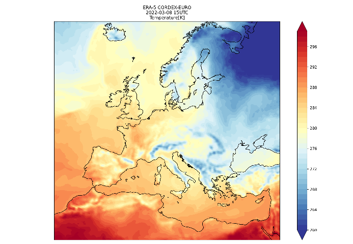
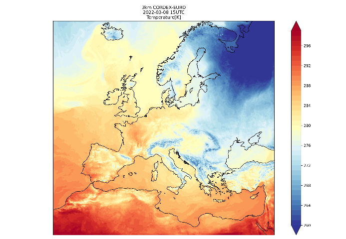
In the first figure we can see a comparison of 2m Temperature between the ERA5 reanalysis, which has a typical resolution of 30km, and our own. They agree well on large scales (a good result, given the shown quality of ERA5 on those scales), but our simulation adds a lot more detail, especially in mountainous regions where individual valleys can be resolved.
 |
 |
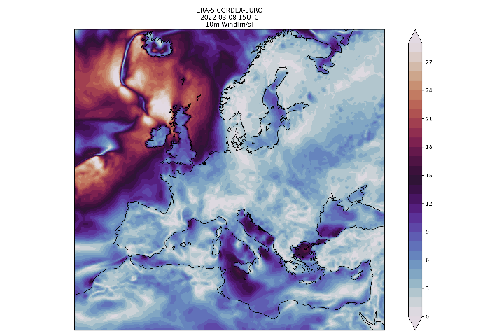
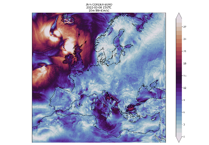
Other advantages of the high resolution can be seen when looking at wind speed. Here, not only are Fronts much more pronounced, the complicated wind systems near and induced by mountains are much more clearly visible (for example near the Adriatic sea), but also over the oceans, where the storm fields of mid-latitude lows show greatly enhanced detail.
 |
 |
In addition, work has started to implement irrigation in “TERRA”, the land surface model that is included with ICON. This will provide a baseline simulation to compare against once the coupled system is running.
Main results in 2023
For the main reanalysis a test period for March-December 2022 was run and evaluated. While initial results looked promising, we saw some greater deviations from observations in areas with especially sparse observation density, such as the oceans. As such we decided to include the assimilation of atmospheric motion vectors (AMV) for the final version of the reanalysis.
Regarding the irrigation parameterization, we worked on a sensitivity experiment with constant irrigation amounts and no time limit. There were a total of 5 different irrigation amounts and one control run with no irrigation for the summer of 2022. The differences between the irrigation experiments and the control run showed the irrigation impact in surface variables.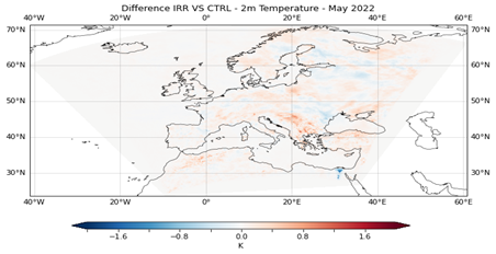
For the land surface reanalysis, we have developed a Python-based assimilation framework that enables the updating of hydrological and ecosystem parameters to improve model predictions. Unlike the tradition Ensemble Kalman Filter (EnKF), the Ensemble Smoother with Multiple Data Assimilation (ES-MDA) allows for the assimilation of multi-type observations over long time periods in a single step, effectively capturing non-linear relationships between model parameters and observations. We have performed extensive simulations for the year 2019 to investigate the influence of different setups. Such as parameter selection, the number of iterations, localization techniques, tapering factors and more.
Li F., W. Kurtz, C.P. Hung, H. Vereecken and H.J. Hendricks Franssen (2023). Water table depth assimilation in integrated terrestrial system models at the larger catchment scale. Frontiers in water, 5, 1150999. https://doi.org/10.3389/frwa.2023.1150999
Main results in 2024
The main reanalysis has started with 2018 and at the end of year reached the end of 2020. It will be continued for the remainder of the project time. In addition, we started to look more into detail into the results, with special interest focusing on precipitation in collaboration with D07. 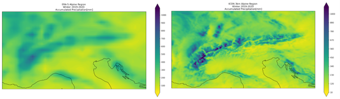

Regarding the irrigation experiments, we investigated results from two simulations considering two irrigation maps for Europe. Moreover, we implemented one new alternative for calculating the irrigation water amount in the parameterization. Also, we implemented irrigation settings that are flexible to the user's need. 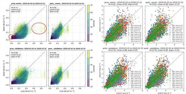
We carried out data assimilation with the land surface model (eCLM) for the year 2019 using both remotely sensed soil moisture retrievals and in-situ evapotranspiration observations. The results were validated against in-situ measurements, showing that parameter updates led to improved estimates of soil moisture and surface heat fluxes across the EURO-CORDEX domain.
Li F., H.R. Bogena, B. Bayat, W. Kurtz, W and H.J. Hendricks Franssen (2024). Can a Sparse Network of Cosmic Ray Neutron Sensors Improve Soil Moisture and Evapotranspiration Estimation at the Larger Catchment Scale?. Water Resources Research, 60(1), e2023WR035056. https://doi.org/10.1029/2023WR035056
Zhao H., C. Montzka, H. Vereecken, H., and H.J. Hendricks Franssen (2024). A Comparative Analysis of Remote Sensing Soil Moisture Data-sets Fusion Methods: Novel LSTM Approach versus Widely-Used Triple Collocation Technique. IEEE Journal of Selected Topics in Applied Earth Observations and Remote Sensing. https://doi.org/10.1109/JSTARS.2024.3455549
Main results in 2025
The reanalysis continues. We found some irregular results for near-surface Temperature which is currently investigated. The impact of this should be negligible for other projects. Additionally, the coupled reanalysis is about to be functional with the upgrade of the coupled ICON version to the 2024.07 public release version.
Currently, there are two ongoing simulations using the operational ICON-NWP in Limited Area Mode, one control and one irrigation experiment, both starting in 2010. The ultimate goal is to cover 13 years of simulation and assess the irrigation impacts across the EURO-CORDEX domain.
We have found that the joint state-parameter data assimilation approach is highly effective in improving soil moisture characterization in land surface model. The eCLM has been run from 2000 to 2022, and after post-processing and validation, we plan to release it as the first version of the land surface reanalysis, with detailed documentation.
Kaandorp M. L. A., C. Poppe Terán, C. Hartick, P. Rigor and H.J. Hendricks Franssen (2025). History matching of soil moisture and evapotranspiration over Europe using iterative ensemble smoothers. Submitted to Journal of Advances in Modelling Earth Systems.
Zhao, H., Montzka, C., Keller, J., Li, F., Vereecken, H., & Hendricks Franssen, H.-J. (2025). How does assimilating SMAP soil moisture improve characterization of the terrestrial water cycle in an integrated land surface–subsurface model? Water Resources Research. (Accepted/In press). https://doi.org/10.22541/essoar.174349969.95856958/v1